

 Rendezvous
Space Surveillance and Satellite Tracking Application
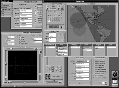
Rendezvous was a space
surveillance/satellite tracking program designed to provide
the user with details of a satellite's position, velocity
orientation, earth coverage area, azimuth, elevation and
range. Several map projections displayed this information
graphically as a ground trace, while text fields and
sliders allowed the user to modify the state parameters and
step the satellite forward or backward in time with the
push of a button. These fields allowed you to view,
convert, and change the parameters in nine different
coordinate systems. Another view showed a display of the
the field of view of the satellite (targets, sun, moon,
stars, earth horizon), as you fly it around the earth.
Features:
- Rendezvous used orbit propagation algorithms developed and used by NORAD, the North American Aerospace Defense Command, and could read the standard two line element sets used by both NORAD and NASA.
- Rendezvous could easily convert between any of the nine major coordinate systems used in the specification of element sets and state vectors. Orientation and bore-sight pointing could be achieved with using any of four coordinate systems.
- Unlike programs on other platforms which provided only textual data, Rendezvous provided users with a real NEXTSTEP interface. Browsers were used to select the sensors and targets to be manipulated, three map projections were used to display the position, ground trace, solar terminator, coverage area, and satellite solar illumination condition. A calendar display was used to interactively set the date and time of the epoch, and the state of the map was updated accordingly. Several buttons were used to step the satellites forward and backward in time. All so intuitively, anyone could become an expert satellite tracker.
What makes Rendezvous best:
a) There was no competition. Rendezvous was the only NEXTSTEP compliant satellite tracking software available.
b) Rendezvous used orbit propagation algorithms developed and used by NORAD, the North American Aerospace Defense Command, and could read the standard two line element sets used by both NORAD and NASA.
c) Rendezvous could easily convert between any of the nine major coordinate systems used in the specification of element sets and state vectors. Orientation and borsight pointing could be achieved with using any of four coordinate systems.
d) Unlike programs on other platforms which provide only textual data, Rendezvous provides users with a real NEXTSTEP interface. Browsers were used to select the sensors and targets to be manipulated, three map projections were used to display the position, ground trace, solar terminator, coverage area, and satellite solar illumination condition. A calendar display was used to interactively set the date and time of the epoch, and the state of the map was updated accordingly. Several buttons were used to step the satellites forward and backward in time. All so intuitively, anyone could become an expert satellite tracker.
e) A tutorial was included which describes how to use Rendezvous for common tasks, including how to find satellites visible from your area, and how to use the Telescope Inspector as a Star Atlas.
Required NEXTSTEP Release 3.1 or higher. Shipped in Multi-Architecture Binary (MAB) format.
Rendezvous was a registered trademark of Visual Understanding. All Rights Reserved.
Alembic Systems International